Simon Willison Releases Datasette Maplibre Plugin
Simon Willison has released datasette-maplibre 0.1a0, a plugin for visualizing geospatial data in Datasette. This plugin combines MapLibre GL and OpenFreeMap, allowing for interactive mapping capabilities.
Original reporting · simonwillison.net
Original: “datasette-maplibre 0.1a0”
Read “datasette-maplibre 0.1a0” at Simon Willison →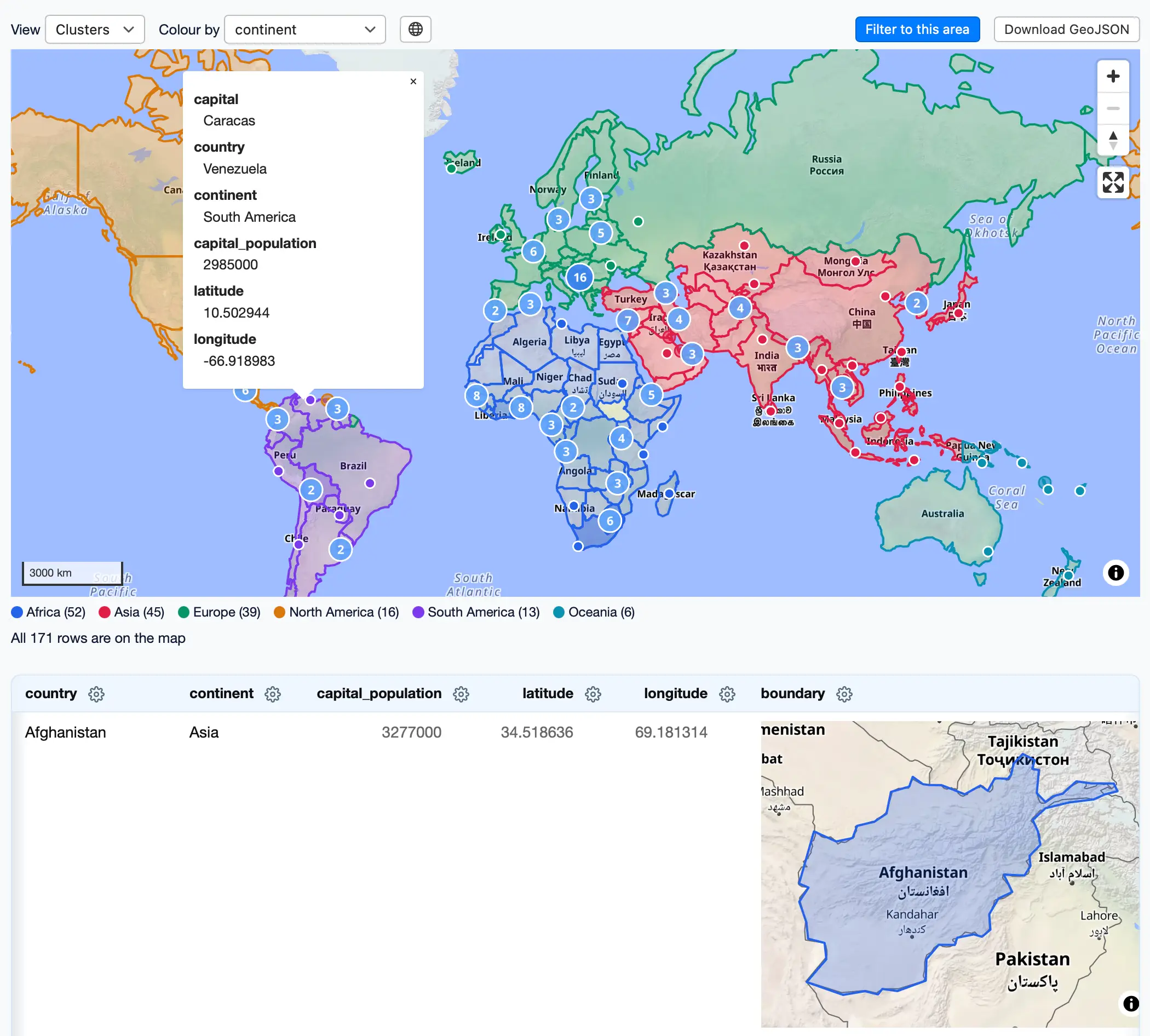
How this was written. GDS wrote this article with a language model from Simon Willison’s reporting (model: @cf/meta/llama-3.3-70b-instruct-fp8-fast); it describes that reporting rather than adding to it. The original, linked above, is the full story.
Key points from Simon Willison’s report
- Simon Willison has released datasette-maplibre 0.1a0, a new plugin for visualizing geospatial data in Datasette.
- The plugin combines MapLibre GL and OpenFreeMap to provide interactive mapping capabilities.
- The plugin includes innovative features such as SVG previews and lazy loading of WebGL previews.
- A comprehensive demo of the plugin is available, which can be accessed via Pyodide and WebAssembly.
- The release of the plugin is sponsored by Dynatrace, a company that specializes in application performance monitoring.
Simon Willison has announced the release of datasette-maplibre 0.1a0, a new plugin for the Datasette platform. According to Simon Willison, this plugin is the first new geospatial plugin for Datasette in some time. The plugin allows users to visualize geospatial data in Datasette using MapLibre GL and OpenFreeMap.
The datasette-maplibre plugin combines the capabilities of MapLibre GL, a mapping library, with OpenFreeMap, a free vector map server operated by Zsolt Ero. Simon Willison reported that he built most of the plugin using a single prompt to Claude Fable 5.2, which generated the initial code for the plugin.
The plugin's development was guided by a prompt that encouraged creativity and thinking outside the box. As a result, the plugin includes several innovative features, such as displaying SVG previews of GeoJSON shapes and loading WebGL previews only when they come into view. This approach helps to improve performance and reduce unnecessary resource usage.
One of the key features of the datasette-maplibre plugin is its ability to work seamlessly with the latest version of Datasette Lite. Simon Willison has made a comprehensive demo available, which can be accessed via Pyodide and WebAssembly. This allows users to test the plugin and explore its capabilities without needing to install any software.
The release of datasette-maplibre 0.1a0 is sponsored by Dynatrace, a company that specializes in monitoring and optimizing application performance. Dynatrace's sponsorship highlights the importance of this plugin in enabling developers to better understand and visualize geospatial data in Datasette.
The datasette-maplibre plugin has the potential to be a valuable tool for developers and users of the Datasette platform. By providing interactive mapping capabilities and innovative features, it can help to unlock new insights and uses for geospatial data. As the plugin continues to evolve, it will be interesting to see how it is adopted and used by the Datasette community.
For those interested in learning more about the plugin and its capabilities, Simon Willison has provided a link to the demo, which can be accessed directly in the browser. This provides a convenient way to explore the plugin's features and see how it can be used to visualize geospatial data in Datasette.
Questions and answers
What is the datasette-maplibre plugin?
The datasette-maplibre plugin is a new plugin for the Datasette platform that allows users to visualize geospatial data using MapLibre GL and OpenFreeMap.
How was the plugin developed?
The plugin was developed using a single prompt to Claude Fable 5.2, which generated the initial code for the plugin.
Is there a demo available for the plugin?
Yes, a comprehensive demo of the plugin is available, which can be accessed via Pyodide and WebAssembly.